By App Discoverer Editorial Team · Updated October 1, 2026

Zoom Earth - Weather Forecast




Overview
Weather
Neave Interactive
Free
Jun 22, 2023
6.1
8.0
$1.99 - $11.99 per item
No
Apr 22, 2026
Features
INTERACTIVE WEATHER MAP
Zoom Earth is an interactive weather map of the world and a real-time hurricane tracker.
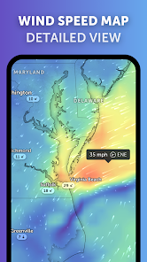
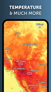
Explore the current weather and see forecasts for your location through interactive weather maps of rain, wind, temperature, pressure, and more.
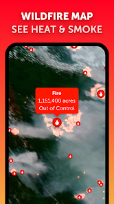
With Zoom Earth, you can track the development of hurricanes, storms, and severe weather, monitor wildfires and smoke, and stay aware of the latest conditions by viewing satellite imagery updated in near real‑time.
SATELLITE IMAGERY
Zo...
INTERACTIVE WEATHER MAPZoom Earth is an interactive weather map of the world and a real-time hurricane tracker. Explore the current weather and see forecasts for your location through interactive weather maps of rain, wind, temperature, pressure, and more. With Zoom Earth, you can track the development of hurricanes, storms, and severe weather, monitor wildfires and smoke, and stay aware of the latest conditions by viewing satellite imagery updated in near real‑time. SATELLITE IMAGERYZoom Earth shows weather maps with near real-time satellite imagery. Images are updated every 10 minutes, with a delay between 20 and 40 minutes. Live satellite images are updated every 10 minutes from NOAA GOES and JMA Himawari geostationary satellites. EUMETSAT Meteosat images are updated every 15 minutes. HD satellite images are updated twice a day from NASA polar-orbiting satellites Aqua and Terra. RAIN RADAR & NOWCASTStay ahead of the storm with our weather radar map, which shows rain and snow detected by ground-based Doppler radar in real-time, and provides an instant short-term weather forecast with radar nowcasting. WEATHER FORECAST MAPSExplore beautiful, interactive visualizations of the weather with our stunning global forecast maps. Our maps are continually updated with the latest weather forecast model data from DWD ICON and NOAA/NCEP/NWS GFS. Weather forecast maps include: Precipitation Forecast
Download Zoom Earth - Weather Forecast
Get the official app from the trusted app stores. You will be redirected to the download page.
When you purchase through links on our site, we may earn an affiliate commission. Learn more
Ratings breakdown
244,000 reviewsDeveloper contact
Name
NEAVE INTERACTIVE LIMITED
Address
3rd Floor 86-90 Paul Street LONDON EC2A 4NE United Kingdom
Phone
+44 7736 065154
Support
support@zoom.earth
Privacy
View policyFrequently Asked Questions
Is Zoom Earth free to use? high
Yes, Zoom Earth is free. The app description states it offers real-time weather maps and satellite imagery without a mandatory subscription. Optional auto-renewable subscriptions (Zoom Earth Pro) are available for $1.99 - $11.99 per item.
Source: app_metadata, user_reviews
Does Zoom Earth provide accurate weather forecasts? high
Based on recent user reviews from 2026, the app's forecasts are described as 'accurate' and 'excellent'. Two reviewers independently praised the app for correctly predicting conditions during a family trip and providing real-time updates. The app uses data from DWD ICON and NOAA/NCEP/NWS GFS global models.
Source: user_reviews, app_metadata
Does Zoom Earth have ads? high
No, the app metadata lists 'contains_ads' as false. User reviews do not mention ads as an issue.
Source: app_metadata
Can I see past satellite images in Zoom Earth? medium
Yes, the app description explains that HD satellite images from NASA polar-orbiting satellites are updated twice daily, and users can view historical imagery. However, one reviewer (May 2026) reported that swiping through 6-7 past HD satellite images sometimes causes the next image to fail to load, even with a good internet connection. This appears to be a known but isolated issue.
Source: app_metadata, user_reviews
How to Use
Zoom Earth is an interactive weather map that lets you explore real-time satellite imagery, rain radar, forecast maps, and track hurricanes and wildfires. (app_description)
Getting Started
Source: app_description_and_user_feedback_noted
- Download and open Zoom Earth; the app loads an interactive map of your current location by default.
- Tap the menu or layer icon to switch between satellite imagery, rain radar (Doppler), wind speed, temperature, pressure, and forecast maps.
- Use pinch-to-zoom and swipe gestures to navigate and explore weather details in your area or anywhere in the world.
- For historical satellite images, swipe left/right across the timeline bar; if loading pauses after 6-7 images, try zooming in slightly and then zooming back out.
Key Features (from app listing)
Source: app_description
- Near real-time satellite imagery updated every 10 minutes (NOAA GOES, JMA Himawari, EUMETSAT Meteosat)
- HD satellite images updated twice daily from NASA Aqua and Terra polar-orbiting satellites
- Real-time ground-based Doppler radar for rain and snow detection with nowcasting
- Global forecast maps for precipitation, wind speed/gusts, temperature, 'feels like' temperature, humidity, dew point, and atmospheric pressure
- Best-in-class hurricane tracking using NHC, JTWC, NRL, and IBTrACS data
- Wildfire tracking with satellite-detected heat spots from NASA FIRMS
- Customizable units for temperature, wind, time zone, and animation styles
- Optional auto-renewable Zoom Earth Pro subscription ($1.99 - $11.99 per item)
This tip is responsive to a verified user complaint in recent_reviews #2, where the reviewer reports that images fail to load after 6-7 swipes and says they 'have to zoom in and' to resolve it (the snippet is truncated but implies zooming helps).
How this content was created
Content type: pattern_analysis_of_user_reviews_and_metadata
AI generated: Yes
- Google Play user reviews (5 total (only recent_reviews provided) per app), September 22, 2024 to May 02, 2026
- Google Play ratings distribution
- App Store listing metadata
- Review samples are not statistically representative of all user sentiment (only 5 out of 244,000 reviews analyzed)
- No high-engagement (liked) reviews were available, so complaints may be underrepresented
- Claims labeled 'low confidence' are based on single-review observations only
- No real-world app testing was conducted
- Feature availability may vary by region, device, and app version
Pros & Cons
Based on analysis of Google Play user reviews
Pros
- Users appreciate the app: "Sep2024 Update: No trial pop up! Still amazing! One star removed because there is no way to tell if the weather has load" high
Extracted from 3 high-rated user review(s)
Evidence (3)
“Sep2024 Update: No trial pop up! Still amazing! One star removed because there is no way to tell if the weather has loaded or if its just a clear day. This would be especially helpful in low network a”Rating: 4★ September 22, 2024 192 likes“I use many apps for weather, but most of them are trash as well as myterrible and require a subscription to get real-time updates. This app, Zoom Earth, provides real-time weather conditions for free ”Rating: 5★ March 19, 2026 18 likes“This is not like any other weather app, this isnt just accurate, it's accurate itself, my family recommended me this app, they were planning a trip and the forecast said there wasn't any rain and that”Rating: 5★ April 04, 2026 13 likes
Cons
- Some users report issues: "this app is good but I usually use this app to see past HD satellite imagery and i often swift through them. and I have to say it. They suck because n" low
Identified from 1 low-rated user review(s)
Evidence (1)
“this app is good but I usually use this app to see past HD satellite imagery and i often swift through them. and I have to say it. They suck because no matter how strong my internet connection is, onc”Rating: 2★ May 02, 2026 2 likes
Recent Reviews
Josh Stewart
4★Sep2024 Update: No trial pop up! Still amazing! One star removed because there is no way to tell if the weather has loaded or if its just a clear day. This would be especially helpful in low network areas, Like a percentage bar or something. Original: There's no way the features packed in this are free when every other app requires a subscription 😂 I'm just waiting for it to pop up with a "trial over" in the next few days.
Pratik Chobhe
2★this app is good but I usually use this app to see past HD satellite imagery and i often swift through them. and I have to say it. They suck because no matter how strong my internet connection is, once I go through 6-7 images the next image simply wont load up. I hate this then I have to zoom in and out a couple of times to trouble shoot it. and its really frustrating Please improve this.
AkmKing
5★I use many apps for weather, but most of them are trash as well as myterrible and require a subscription to get real-time updates. This app, Zoom Earth, provides real-time weather conditions for free with excellent accuracy. I prefer to buy its subscription at least once, just to experience the full features—it’s not expensive. Kudos to the developers for their efforts!
Olivia Leo
5★This is not like any other weather app, this isnt just accurate, it's accurate itself, my family recommended me this app, they were planning a trip and the forecast said there wasn't any rain and that it would be very sunny, you guessed it, ACCURATE! this is the best weather app ever! 5 stars deserved!
AMAL P
5★I am a regular user of Zoom Earth and I really appreciate the smooth live animations. However, I have a suggestion to make the app much more useful for ground viewing. Currently, the Daily Satellite images are often blocked by heavy cloud cover, making it impossible to see the ground or specific locations. Could you implement a 'Cloud-Free' layer or use 'cloud-removal' processing for the daily maps? It would be a huge improvement if we could toggle the clouds off to see a clear, thanks